Ward's Div. Deployed
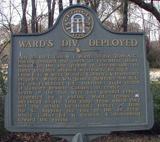
July 20, 1864. Gen. W. T Ward´s 3rd Division , 20th A.C. having crossed the creek at Peachtree Road, moved to the low ground at stream-side, its three brigands aligned westward, facing S. From East to West were Wood´s, Coburn´s and Harrison´s brigades. Wood´s left joined Newton´s 4th A.C. division on Peachtree Road. Harrison´s right rested at Tanyard Branch: Coburn´s at center.
South of the flat were two parallel ridges, separated by a ravine. Ward´s troops [Federal] advanced to the first ridge from which they met the attack by Hood´s forces [Confederate] from the South, topping the rise on the 2d ridge where Collier Road is located and descending toward the ravine.
GHM 060-32 - Georgia Historical Commission - 1955
Plaque courtesy Lat34North.com.
Original page, with additional info, here.
Photo credit: Byron Hooks of Lat34North.com.